Municipal Street Void Survey
Location: Florence, Kentucky
Client: City of Florence
Services: Geophysics
Overview:
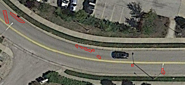
Geotechnology performed a ground penetrating radar (GPR) survey to detect voids beneath approximately 3,700 lineal feet of streets within the City of Florence, Kentucky.
Municipal Street Void Survey Project Background
GPR is a geophysical technique in which a broadband EM signal is transmitted into the ground. The signal is then reflected by subsurface features based on contrasts in dielectric permittivity and conductivity. Underground features such as voids often exhibit high amplitude reflections.
The survey was performed using a GSSI SIR 3000 GPR system with a 400 MHz antenna. GPR data was collected along parallel lines spaced approximately one foot apart over the pavement. Additionally, we generated and analyzed three-dimensional (3D) data for the presence of voids using Radan software. Processing included surface normalization and horizontal full-pass filtering. It also involved low and high pass filtering as well as migration of hyperbolas.
The GPR data were reviewed for the presence of high-amplitude reflections indicative of sub-slab voids. Locations of high-amplitude reflections interpreted as potential voids were mapped and provided to the City. The City included this data in their public works improvement program.